PLANETARY EXPLORATION / MISSION OPERATIONS
How a Robot Finds Its Way Across Another Planet
Explore how cameras, orbital maps, engineering teams, and autonomous navigation software help Mars rovers travel safely across unfamiliar terrain.
Driving across Mars is nothing like driving a vehicle on Earth. There are no paved roads, traffic signs, or satellite navigation systems guiding a rover toward its destination.
Instead, robotic explorers must travel across rocky plains, steep slopes, sandy surfaces, and landscapes that scientists have never examined directly.
Every movement involves decisions about safety, scientific value, and available energy.
A route that looks short on a map may contain sharp rocks, loose sand, or terrain capable of trapping a rover.
Another path may be longer but provide safer ground and better opportunities for scientific observations.
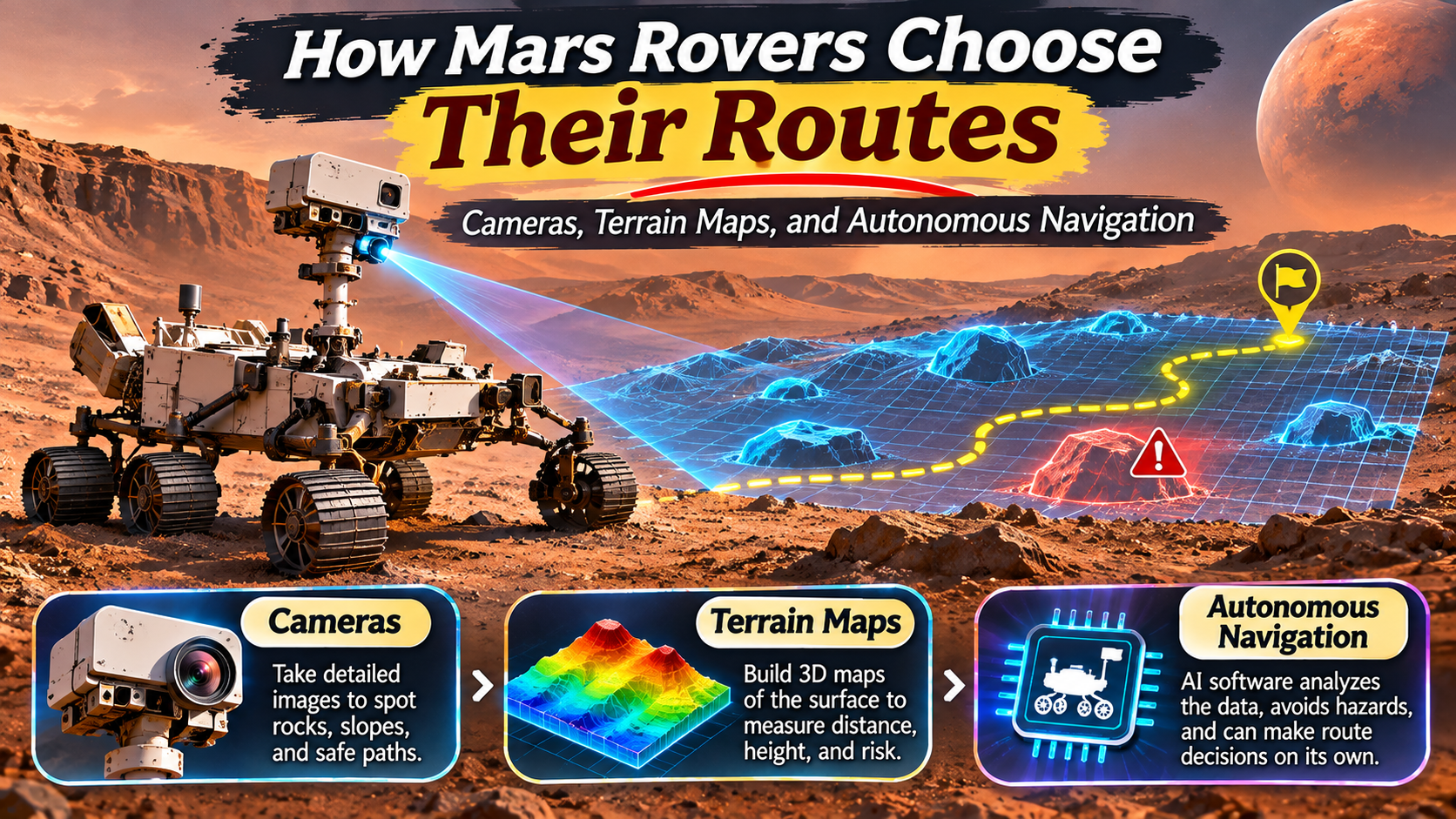
Mars rovers navigate through a combination of human planning, camera observations, terrain mapping, and onboard autonomous software.
Modern rovers can recognize some hazards and make local driving decisions without waiting for individual commands from Earth.
Understanding how this process works reveals one of the most impressive achievements in robotic planetary exploration.
Why Driving on Mars Is So Difficult
Mars presents several challenges that make surface navigation complicated.
The planet has an uneven landscape shaped by ancient water activity, volcanic processes, impacts, wind, and geological change.
Rovers encounter rocks, sand ripples, crater rims, slopes, and areas where the ground may not support their wheels reliably.
Loose soil can cause wheels to slip or sink.
Large rocks may damage wheels or interfere with the rover’s underside.
Steep terrain can create stability problems.
Engineers must also consider the rover’s mechanical capabilities, available power, communication opportunities, and scientific objectives.
Unlike a human driver, a rover cannot simply look through a windshield and respond instantly to instructions from Earth.
Radio communication delays make direct remote driving impractical for continuous movement.
Why Scientists Cannot Drive Mars Rovers in Real Time
Mars and Earth are separated by enormous distances that change as both planets orbit the Sun.
Radio signals travel at the speed of light, but they still require several minutes to move between the planets.
Depending on the relative positions of Earth and Mars, one-way communication delays can range from roughly 3 to more than 20 minutes.
This means an engineer cannot safely operate a rover with the immediate feedback available in a remote-controlled vehicle on Earth.
By the time an image reaches mission control, the rover’s surroundings may already have changed if it is moving.
Sending a correction requires additional travel time for the command signal.
Instead, mission teams prepare instructions that the rover can execute during a planned operating period.
Onboard systems handle many immediate decisions related to movement and safety.
MISSION CONTROL FACT
A Mars Rover Cannot Depend on Instant Instructions from Earth.
Communication delays require mission planners to send carefully prepared commands and rely on onboard systems for local navigation decisions.
Step 1: Cameras Reveal the Terrain Ahead
Cameras are among the most important tools used for rover navigation.
They provide images of the surrounding landscape, allowing engineers and onboard software to identify rocks, slopes, and other features.
Mars rovers carry different cameras for navigation, engineering, and scientific observations.
Navigation cameras help reveal the terrain around the vehicle.
Hazard-avoidance cameras provide views of nearby ground and obstacles.
Scientific cameras can examine distant geological features and potential research targets.
Some camera systems capture overlapping images from different viewpoints.
These images can be used to estimate the distance and shape of nearby objects.
The resulting three-dimensional information helps the rover determine where it can travel safely.
How Stereo Vision Helps Rovers Understand Distance
Human eyes estimate depth partly because they view the same scene from slightly different positions.
Stereo camera systems use a similar principle.
Two cameras capture overlapping views of the landscape.
Software compares corresponding features in the images to estimate their distance from the rover.
These measurements can help create three-dimensional terrain representations.
The rover can then identify raised obstacles, depressions, and changes in ground elevation.
This information is especially valuable when navigating through areas containing numerous rocks.
Step 2: Terrain Maps Help Identify Safe Routes
Images alone are not enough to plan a successful journey.
Mission teams also use terrain maps to understand the broader landscape.
Orbital spacecraft provide images of the Martian surface from above.
These images can reveal craters, ridges, dunes, and geological formations across large areas.
Scientists combine orbital information with observations collected by the rover.
The resulting maps help identify possible routes toward scientific destinations.
However, orbital images cannot reveal every small rock or local hazard.
That is why close-range camera observations remain essential.
Route planning involves combining regional knowledge with detailed information about the ground immediately ahead.
MISSION OPERATIONS / TERRAIN ASSESSMENT
Relatively level ground, manageable obstacles, and surfaces expected to provide adequate traction.
Uneven ground, moderate slopes, scattered rocks, or uncertain surface properties.
Large obstacles, steep slopes, deep sand, unstable surfaces, or areas exceeding rover safety limits.
Illustrative categories only. Actual rover hazard assessments use mission-specific measurements, thresholds, and software.
Step 3: Engineers Choose Scientific Destinations
Mars rovers are not designed simply to travel as far as possible.
Their primary purpose is scientific exploration.
Mission teams select destinations based on research objectives, geological interest, and operational feasibility.
A rover may be directed toward a rock formation that could preserve evidence of ancient water.
Another destination may contain sedimentary layers that reveal information about the planet’s environmental history.
Scientists and engineers work together to balance scientific opportunities against navigation risks.
A particularly interesting target may require a longer or more difficult route.
Mission planners must determine whether the potential scientific value justifies the additional time and operational challenges.
Route selection therefore involves both exploration strategy and engineering judgment.
Step 4: Autonomous Navigation Software Plans Local Movement
Modern Mars rovers can perform certain navigation tasks autonomously.
Autonomous navigation allows the rover to evaluate nearby terrain and select safe local paths within the limits established by mission planners.
The rover uses camera images and onboard processing to identify obstacles.
It can then assess possible driving directions.
Instead of following every planned movement blindly, the rover may adjust its route to avoid hazards.
This capability reduces the need for engineers to specify every small steering correction.
It can also allow the rover to travel farther during suitable driving opportunities.
However, autonomy does not mean the rover independently chooses its overall scientific mission.
Human teams still determine major objectives, operating constraints, and destination priorities.
How Perseverance Uses AutoNav
NASA’s Perseverance rover includes an advanced autonomous navigation system known as AutoNav.
The system allows the rover to process terrain information and make local route decisions while driving.
Perseverance uses onboard computing and camera observations to identify potential hazards.
Its navigation capabilities represent an improvement over earlier Mars rover systems.
Autonomous driving is particularly useful when a rover must cross relatively long stretches of unfamiliar terrain.
Nevertheless, difficult conditions may still require careful human planning or more conservative driving procedures.
The Rover Navigation Workflow
ROUTE PLANNING / OPERATIONAL SEQUENCE
Collect camera images and available terrain measurements.
Identify rocks, slopes, surface conditions, and possible hazards.
Select a scientifically valuable target and define operating constraints.
Follow planned commands while onboard software handles permitted local adjustments.
Analyze the rover’s position, observations, and engineering data before further planning.
How Rovers Estimate Their Position Without GPS
Mars rovers cannot rely on a global navigation satellite system equivalent to GPS on Earth.
Instead, they estimate their position using onboard sensors and observations.
Wheel rotation measurements can provide information about movement.
However, wheel slip can make these estimates inaccurate.
Visual odometry helps address this problem.
The rover captures images of the ground and tracks recognizable features between successive observations.
By comparing how these features appear to move, software can estimate the rover’s motion relative to the terrain.
Other sensors help measure orientation and movement.
Mission teams combine this information with mapping and navigation data to track the rover’s progress.
Position estimates still contain uncertainty, so careful navigation planning remains important.
Why Sand and Rocks Are Major Navigation Hazards
Some of the most serious risks for Mars rovers come from ordinary-looking terrain.
Loose sand can reduce traction and cause wheels to sink.
NASA’s Spirit rover became stuck in soft Martian soil in 2009.
Although engineers attempted to recover it, the rover could not resume normal driving.
Spirit’s experience demonstrated the importance of understanding surface conditions.
Sharp rocks also create risks.
NASA’s Curiosity rover experienced wheel damage associated with travel over challenging rocky terrain.
Mission teams adapted driving strategies to reduce further wear.
These examples show why rover navigation involves more than simply avoiding large visible obstacles.
Engineers must consider how wheels interact with different types of ground.
How Mars Rover Navigation Has Improved
Mars rover navigation has advanced significantly over successive missions.
NASA’s Sojourner rover, which landed in 1997, demonstrated early robotic mobility on Mars.
Spirit and Opportunity, which landed in 2004, expanded the use of autonomous navigation and long-distance surface exploration.
Curiosity, which landed in 2012, introduced additional capabilities for navigating complex geological terrain.
Perseverance, which landed in 2021, uses more advanced onboard processing and autonomous navigation systems.
Each generation has benefited from improvements in sensors, computing, mobility systems, and operational experience.
These advances allow modern rovers to handle more navigation decisions locally while remaining under human mission supervision.
Comparing Mars Rover Navigation Systems
| Rover | Landing Year | Navigation Development |
|---|---|---|
| Sojourner | 1997 | Early autonomous obstacle avoidance |
| Spirit and Opportunity | 2004 | Expanded autonomous navigation and surface mobility |
| Curiosity | 2012 | Advanced terrain assessment and autonomous driving |
| Perseverance | 2021 | Faster onboard terrain processing and advanced AutoNav |
How Route Planning Supports Scientific Discoveries
Navigation technology directly influences the scientific results a rover can achieve.
A rover that can travel safely between research sites has access to a wider range of geological features.
It can investigate different rock layers, examine changes in surface materials, and reach locations selected for sampling.
For example, Perseverance explores Jezero Crater, an area containing geological features associated with an ancient lake and river delta.
Navigation planning helps the rover reach scientifically important locations while managing operational risks.
Scientists can then use onboard instruments to investigate rock composition, geological history, and evidence relevant to past environmental conditions.
Route planning is therefore an essential part of planetary science rather than a separate engineering task.
The Future of Autonomous Navigation on Mars
Future planetary exploration missions may use increasingly capable autonomous systems.
Improved onboard computing could allow robotic explorers to process more terrain information without constant assistance from Earth.
Advanced visual navigation may help rovers recognize complex obstacles and evaluate alternative routes.
Future systems may also support coordinated exploration involving multiple robotic vehicles.
However, autonomous navigation must remain reliable in unfamiliar environments where mistakes can have serious consequences.
Engineers must balance independent decision-making with strict safety requirements.
As robotic exploration expands, navigation technology will remain central to reaching difficult and scientifically valuable destinations.
Frequently Asked Questions
How do Mars rovers know where to go?
Mission teams select scientific destinations using orbital maps and rover observations, while onboard navigation software helps identify safe local routes.
Can Mars rovers drive themselves?
Modern Mars rovers can perform certain autonomous navigation tasks, including identifying obstacles and making local driving adjustments within mission-defined limits.
Why can’t scientists control rovers in real time?
Radio signals take several minutes to travel between Earth and Mars, making continuous real-time remote driving impractical.
Do Mars rovers use GPS?
No. They estimate their position using camera observations, wheel measurements, onboard sensors, and mapping information.
What cameras help Mars rovers navigate?
Navigation cameras and hazard-avoidance cameras provide important information about surrounding terrain and nearby obstacles.
What happens if a rover encounters dangerous terrain?
Depending on its capabilities and commands, the rover may adjust its local route, stop, or wait for further instructions from mission control.
Why is autonomous navigation important for future Mars missions?
It can reduce dependence on detailed Earth-based driving commands and help robotic explorers travel efficiently across unfamiliar terrain.
Final Thoughts
Mars rover navigation combines advanced engineering with scientific exploration.
Cameras reveal nearby obstacles, orbital images provide broader terrain context, and onboard sensors help estimate movement.
Human teams choose destinations based on scientific value and operational safety.
Autonomous navigation software allows modern rovers to make selected local decisions without waiting for individual commands from Earth.
These capabilities are especially important because communication delays prevent continuous real-time control.
From Sojourner to Perseverance, each generation of Mars rovers has expanded the possibilities of robotic exploration.
As future missions become more ambitious, reliable autonomous navigation will help explorers travel farther and investigate increasingly challenging landscapes.
Every successful rover drive represents a carefully coordinated effort between human planning and robotic intelligence.